Muddy Towpaths, Tidy Deliverables: The Canal Survey Flights That Get Commissioned
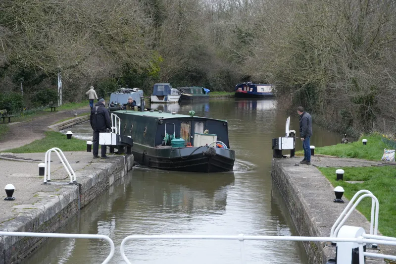
Canals look like an easy flying day: flat water, straight lines, nice reflections. Then you arrive at a lock, find a two-metre towpath, a moored narrowboat, an angler who was there at dawn, and a bridge parapet that blocks your line of sight. Canal work is not a scenic jolly. It is a linear asset survey with a public right of way running through the middle of it. Do it properly and there is repeat maintenance money in it.
The asset is linear, so the flight plan has to be too
A field survey is a grid. A canal survey is a corridor. You are not mapping 40 hectares; you are inspecting a ribbon of masonry, embankment, vegetation and water infrastructure that happens to be 250 years old and carries boats, walkers, cyclists and fishermen every day.
That changes everything. Battery planning is about distance along the cut, not area. Line of sight is interrupted by bridges and bends. Launch sites are scarce and shared. And the client — usually a trust, a contractor, a local authority or a marina operator — does not want a pretty video. They want evidence they can put into an asset register and a maintenance budget.
Permission is the first flight control
In England and Wales, most of the network is managed by the Canal & River Trust. Scotland has Scottish Canals. Both have processes for commercial drone work, and neither is a rubber stamp. Expect to provide operator credentials, public liability insurance, a method statement, a site-specific risk assessment, flight dates, corridor maps and a data handling note. Lead times are real. If you turn up in June hoping to fly in June, you will be disappointed.
The towpath is usually owned or managed by the same body, so launching from it is a landowner permission question, not just a CAA question. Local authority parks, highway verges and private wharves bring their own consents. Angling clubs may hold fishing rights on the bank even where the trust owns the soil. Ask early, ask in writing, and keep the replies in the job folder.
Launch sites: the two-metre rule
Good canal launch spots are wide lock approaches, wharves, winding holes and maintenance compounds. Bad ones are bridge pinch points, lock landings, mooring bollards and anywhere a boat needs to pass. Keep your footprint to roughly the space of a picnic blanket. One pilot, one spotter, one case. No sprawling ground station, no tripod forest, no cones unless the client has agreed them.
Mud is the other factor. A towpath in February is a slippery strip between water and nettles. Wear boots you can hose down, put the case on a mat rather than the ground, and keep spare batteries in a LiPo bag inside a waterproof layer. If the site is genuinely too narrow, fly from a nearby bridge only with permission and never from the carriageway, and consider a short-handled landing mat that can be pegged down.
The shot list asset managers actually pay for
Locks are the highest-value target. Capture upstream and downstream gate leaves, mitre posts, paddle gear, the cill, brickwork and coping stones. Oblique stills show condition; a nadir or near-nadir run over the chamber gives context. If boat traffic allows and the client wants it, a short clip of a gate cycle is useful — but never interfere with a boat crew working the lock.
Bridges need deck, parapet, soffit, abutments, wing walls and the waterline at piers where scour shows up. Orbits and obliques from both banks are more useful than one hero shot. Look for vegetation growing out of mortar, missing pointing, cracked spandrels and blocked drainage.
Embankments are where linear ortho strips earn their keep: slippage, seepage, animal burrows, eroded crests and encroaching scrub. Culverts, weirs and trash screens need inlet and outlet coverage, plus a note of any debris that could block flow. Tie every image to an asset ID, because a folder of 400 JPEGs called DJI_0042 is not a survey.
Deliverables should be agreed before take-off: georeferenced stills, a defect register with condition grades, an annotated PDF keyed to asset numbers, a short clip for the stakeholder meeting, and the flight log. That package is what gets you the next call.
Boaters, anglers, walkers: the social side
Boaters are not obstacles; they are the reason the asset exists. Do not hover over a moving boat, do not buzz a lock landing, and do not assume rotor wash is harmless just because your drone is small. Moored boats are people's homes. Keep the camera off interiors and windows, and brief the client on privacy before you publish anything.
Anglers have lines in the water and often decades of local knowledge. Ask before you fly over a swim, keep your distance, and avoid early morning if you can. Walkers, cyclists and dogs need a spotter who is actually watching the path, not the screen. On a busy summer towpath, the honest answer is sometimes to fly early, fly late, or come back another day.
A 2026 rules checklist
Before the wheels leave the case: valid Operator ID and Flyer ID, correct class marking, remote ID where required, and a flight category that matches the operation. Commercial work needs insurance. Check the NATS drone safety map, NOTAMs, flight restriction zones and any local byelaws. Confirm Canal & River Trust or Scottish Canals permission, landowner consent and any park or highway permission. Have a risk assessment, method statement and emergency plan on site. Remember wildlife law: nesting birds and bats in bridges are not a paperwork detail, and an ecologist may need to advise before you fly close to a roost.
Kit that survives a towpath in February
A compact folding drone with three batteries, a LiPo-safe bag, a waterproof hard case, a small landing mat, wellies, waterproof trousers, a hi-vis vest, a head torch, a kneepad, lens cloths, desiccant sachets, a tablet hood and a power bank. Add a two-way radio if you are working with a spotter at distance, and a hand warmer if you want your fingers to work the gimbal dial. That is the whole list. Narrow sites punish over-packing.
Turning one flight into a repeat contract
Consistency is the commercial trick. Use the same asset naming, the same condition grades and the same delivery format every time. Upload to the client's portal if they have one, turn the job around quickly, and flag the defects that need a human inspector rather than pretending a drone image is a structural report. Quote per asset or per kilometre of corridor, not per flight, and offer an annual repeat. The canal network is long, old and permanently short of condition data. Fly it neatly and you will be back.